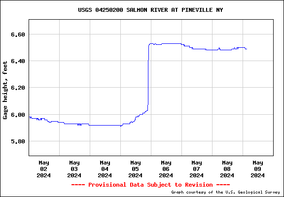
Historical Gage Height in Feet

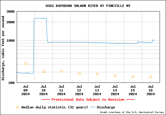
Historical Discharge Flow in Cubic Feet Per Second

How do I interpret gage height and streamflow values?
Historical Discharge Flow in Cubic Feet Per Second
How do I interpret gage height and streamflow values?
Gage height (also known as stage) is the height of the water in the stream above a reference point. Gage height refers to the elevation of the water surface in the specific pool at the streamgaging station, not along the entire stream. Gage height also does not refer to the depth of the stream. Measurements of gage height are continually recorded by equipment inside a gagehouse on the streambank.
Streamflow (also known as discharge) is the volume of water flowing past a given point in the stream in a given period of time. Streamflow is reported as cubic feet per second (ft3/s). Streamflow values are better indicators than gage height of conditions along the whole river. Measurements of streamflow are made about every six weeks by USGS personnel; they wade into the stream to make the measurement or do so from a boat, bridge, or cableway over the stream.
For each streamgaging station, a relation between gage height and streamflow is determined by simultaneous measurements of gage height and streamflow over the natural range of flows (from very low flows to floods). This relation provides the current condition streamflow data from that station. All current condition data are provisional and subject to revision.
